
|
| Our subscribers' grade-level estimate for this page: 4th - 5th |
| Go to Answers | Map Reading Activity: Topography |
Geography Pages |
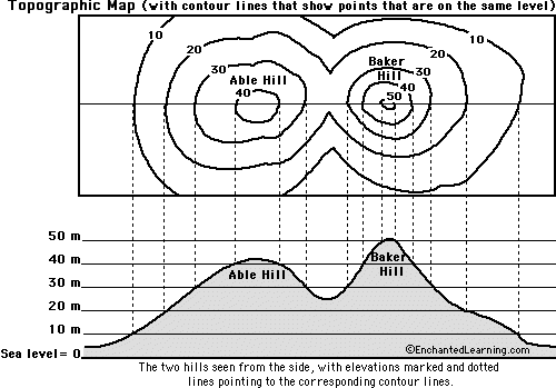
| 1. Color the elevations on the topographic map as follows. Red: 50m and higher, Orange: 40-50m, Yellow: 30-40m, Light green: 20-30m, Dark green: 10-20m, Purple: 0-10m. |
| 2. Approximately how tall is Able Hill? | ___________________________ |
| 3. Approximately how tall is Baker Hill? | ___________________________ |
| 4. Which mountain is taller, and by about how much? | ___________________________ |
| 5. How many meters of elevation are there between contour lines on the topographic map? | ___________________________ |
| 6. Which mountain has steeper slopes? | ___________________________ |
| 7. Are the contour lines closer together on Able Hill or Baker Hill? | ___________________________ |
| Search the Enchanted Learning website for: |